We just had a neat one go overhead. I've only seen one other while taking off at CLT. Those props are loud!


It flies out of Johnston regional quite regularly. It’s some sort of cargo plane. They also fly a C47. Of course they are shell companies that own themSomeone posted about a CIA aircraft flying around RDU for 6-7 hours this past weekend.
C-17 Globemaster?Epic41 just came scooting the house again. 400kts@2300ft
C-17 Globemaster?
What he said.Which is the better app ? FlightAware or FlightRadar

 www.wltx.com
@Mirac too…What he said.
I don't think anyone responded.
I'm curious too and I wish someone would offer an opinion. Please.
If y'all ain't figured it out yet, I'm always way late to the party and this is no exception. It's probly old hat to you guys and I'm just finding out this ability exists. I think it's cool as all !!!!
For whatever reason I've always paid attention to aircraft, wondering who and what, the origin and destination, seen pairs, triples, quads, thinking probly military. And this info is readily available, who woulda thunk it??
Seymour flys out here regularly. Its probly 3 miles tops as the crow flies to Joco airport. Theres lots of traffic in the air here.
Im also curious about where the info comes from and how it ends up accessible to the end user.
I was telling someone about it today and they swore, "no way you can access that data." I'm sorry but yes you can i replied.
So c'mon guys give us/me the lowdown.
It flies out of Johnston regional quite regularly. It’s some sort of cargo plane. They also fly a C47. Of course they are shell companies that own them
Yes sir the Douglas Skytrain from the 1940’s, the civilian model is a DC3A C-47??
Yes sir the Douglas Skytrain from the 1940’s, the civilian model is a DC3


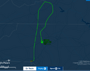
Could be aerial imagery for a county(ies) and/or LiDAR mapping. Although that is a large footprint for such a venture. It's usually done on a county scale or smaller.
I was thinking similar. I'm watching it, will be interesting to see how big of an area it ends up covering.Could be aerial imagery for a county(ies) and/or LiDAR mapping. Although that is a large footprint for such a venture. It's usually done on a county scale or smaller.
For those that have interest, I recommend: https://flightaware.com/adsb/piaware/build/
For a wee bit more than $125 you can have your own receiving station and stare endlessly at whats what. Sure you can get some info online free at no effort, but if you are even the slightest bit geeky ( and I know theres Hams on this board) the DIY thing is satisfying. Also you get a free Enterprise account on FA.
Sure-absolutely - might get someone started enough to decide if they want to go further and get better gear. ( down the rat hole )A RTL-SDR dongle and dump1090 will do pretty much the same thing for $30.
No enterprise account going that route but far more functional as you can use the rtl-sdr for a ton of other things.
<- ham 😉


Not my house, but the army seems to be having a helicopter festival in Alabama. I counted at least 20 in a relatively small area.
View attachment 472716
These are based up in Norfolk and are owned by ATAC. They provide contract adversarial planes for the US military. I normally see them offshore north of Hatteras.
F14 s from Seymour Johnson

Not my house, but the army seems to be having a helicopter festival in Alabama. I counted at least 20 in a relatively small area.
View attachment 472716
Is that a premium version? Mine doesn’t tag the type of aircraft like that. You have to tap it to see that info.